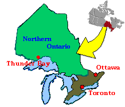
Northern Ontario Council was formed in 2002 with the amalgamation
of the Northwestern Ontario Region and Great Northern
(Northeastern Ontario) Region. The Northern Ontario Council looks
after the area between the Quebec Border and the Manitoba Border,
and from the French River north to the South shore of Hudson
Bay.
The Council straddles the Eastern and Central Time
Zones.
The Council is sub-divided into 12 Areas:
The Ken-Kee Area covers from
Sioux Narrows north to Grassy Narrows and from Willard Lake west
to the Manitoba Border. Ken-Kee includes Kenora and Keewatin on
the shores of Lake-of-the-Woods, from which it gets its name;
The Sunset Area, is from
White Otter Lake north to McKenzie Island, and from English River
west to Vermillion Bay on Highway 17. Includes Ignace, Sioux
Lookout, Dryden, Red Lake and Ear Falls;
The Rainy River Area in the
Southwest, is from Kawene west along Highway 11 to Rainy River,
and from the US Border north to to Nestor Falls on Highway
71.
The Thunder Bay Area From
Nipigon in the east to the Quitico Provincial Park Boundry on
Highway 11 and the town of Upsala on Highway 17 in the west, and
north from the US Border to Garden Lake, including Armstrong and
the City of Thunder Bay and it's rural suburbs.
The Nipigon Bay Area, from
the town of Nipigon to Long Lac along Highway 11, including
Orient Bay, Beardmore and Geraldton;
Lake Superior Area, along the
North Shore of Lake Superior, from Schrieber to White River, and
from Marathon to Manitouwadge and Hornepayne on Hwy 631;
Points North Area, from Wawa, east to Chapleau and north to
Kapuskasing on Hwy 11;
Black River Area, along Hwy 11 including Iroquois Falls,
Cochrane, Matheson, New Liskeard, Englehart and Elk Lake;
Porcupine Area, Timmins and surrounding area, southwest on hwy
101 to Folyete, northeast to Connaught;
Sault Ste. Marie Area, from Batchawana Bay to Sault Ste. Marie
and surrounding areas, east on hwy 17 to include Blind River, and
the top of Elliot Lake on Hwy 108;
Sudbury Area, Hwy 17 east from Blind River to Verner, north on
Hwy 144 to Cartier, and south to French River;
Nipissing Area, from North Bay on Hwy 17 west to Sturgeon
Falls, east to Mattawa, on Hwy 11, north to Temagami and south to
Sundridge;
Council-Direct Service groups are Gogama, Hearst, communities
along Hwy 599 and the James Bay coast.
The Council hosts Scouting activities in all sections, Camps,
Kub Kar Rallys (called Pinewood Derby in the USA), 18 Wheeler
Rallys, (the Scout equivalent to Kub Kars) where the older youth,
and leaders, build and race Transport Trucks.
Council Cub and Scout Camps are held in the Fall, Winter and
Spring, and are open to all Cubs, Scouts, Venturers and Rovers.
Anyone wishing to attend from outside Northern Ontario Council
will be welcomed.
For more information contact
|
 |