 |
Uniform Badges worn in Northwestern Ontario
 |
|
|
|
|
|
|
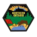
Northern Ontario Council |
| |
The Council badge is representative of the region: Northern
Lights, Forrest, Camping, Lakes, Moose and Bear. The Region stretches
across the top of Ontario, from Quebec to the Manitoba
Border. |
 |
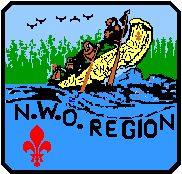 |
The N.W.O. Region Badge is a Freighter Canoe
paddled by Voyagers, with pine trees in the background and the
blue clear waters of the regional lakes in the foreground. A red
scout symbol is in the lower left corner. A flight of Ravens, for
which the area is famous, overlooks from the left top. |
|
|
|
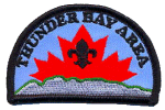
Thunder Bay Area
|
|
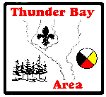
2001 - 2004 |
Thunder Bay Area was formed in March of 2001, and
replaces the Districts of Thunder Bay North and Fort William. The
badge contains elements representative of the history, geography
and culture of the Thunder Bay area. Outlined in the background
is the famous Kakabeka Falls on the Kaministiquia River. A black
fleur-de-lis is on the rock outcrop at the edge of the falls. The
four season wheel wheel represents the native tradition and
culture in the Thunder Bay area and provides the colour scheme
for the badge. The sillouhette of the coniferous trees in the
lower left corner represents the boreal forest and its importance
to the economy of the area.
This badge was designed by Scouter Peter K. Waycik, a local
leader, badge collector and member of the Canadian Badgers
Club.
|
|
|
|
|
|
The City of Thunder Bay's eastern horizon is
dominated by the Sleeping Giant. In this badge, the Scouts Canada
Logo is rising in the east from behind the Sleeping Giant, into
the clear blue sky that Northwestern Ontario is noted for. This
second Thunder Bay Area badge was designed by the youth.
|
2004 - ���� |
|
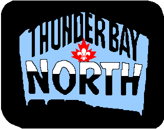
Thunder Bay North District
|
|
1996 - 2001 |
The Port Arthur District formally changed its
name to "Thunder Bay North District" in the spring of 1996. The
new district badge is dark navy blue with light blue sky over the
"Sleeping Giant". The letters forming "Thunder Bay" hang like
icicles from the entrance to a cave, and the word "North" is
covered with snow, a common occurrence from October through April
in Thunder Bay North. The center of the badge shows the
Scouts Canada fleur-de-lis in a red maple leaf.
In March 2001, Port Arthur District became part of the Thunder
Bay Area.
|
|
|
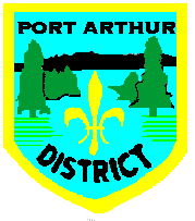
The Port Arthur District badge shows the
"Sleeping Giant" a land mark seen from all over the city of
Thunder Bay, the blue waters of Lake Superior, and evergreen
trees, a major economic resource of the district.
This badge is no longer available.
|
 |
|
Fort William District
|
|
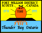 |
The Cities of Fort William and Port Arthur were
amalgamated by the Ontario Government in 1971. To Commemorate the
25th Anniversary of the forming of the City of Thunder Bay, the
Fort William District designed a special Anniversary District
Badge, to be issued upon registration in the District for each of
the Scouting years, 1995-6 and 1996-7. This Badge is to be worn
on the Uniform only by members registered during the Anniversary
year.
|
|
|
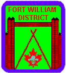
The Fort William District Badge has the Scouts
Canada Logo surrounded by the log gates of Fort William, a
Hudson's Bay Company Post on the Shores of Lake Superior, and the
founding of the City.
This badge is no longer available.
|
 |
|
Lake Superior Area
|
|
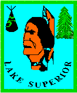 |
Lake Superior Area, along the north shore of Lake
Superior, includes the towns of Marathon, Manitouwadge,
Schreiber, Terrace Bay,Hornepayne and White River.
|
|
|
Nipigon Bay
|
|
|
The Nipigon Bay Area, from the town of Nipigon
to Long Lac along Highway 11, including Orient Bay, Beardmore and
Geraldton.
Transportation, Mining, and Logging are the area's main
resources.
The town of Long Lac on Highway 11 is renowned for its Canoeing
Adventures along rivers and lakes teaming with fish. The towns of
Geraldton and Beardmore were the sites of the Gold Rush during
the first half of 20th century.
|
|
|
Kenogamisis District
|
|
|
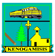
Transportation (Railway Locomotive on the Top),
Mining, and Logging are the area resources depicted in this
district badge. Kenogamisis District covers the area around the
town of Long Lac on Highway 11; Renowned for its Canoeing
Adventures along rivers and lakes teaming with fish, and the Town
of Geraldton, which was the site of the Gold Rush during the
first half of this century. Kenogamisis is part of the North East
Area.
|
 |
|
Sunset Area
|
|
|
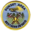 |
The Sunset Area stretches from White Otter Lake
north to McKenzie Island, and from English River west to
Vermillion Bay on Highway 17. This area, famous for Gold mines, forestry
and Canoeing adventures, includes the towns of Ignace, Dryden,
Sioux Lookout, Ear Falls, Red Lake and Cochenour.
|
|
|
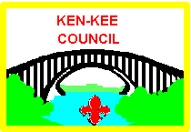
Ken-Kee Area
|
|
|
The Ken-Kee Area covers from Sioux Narrows
north to Grassy Narrows and from Willard Lake west to the
Manitoba Border. Ken-Kee includes Kenora and Keewatin on the
shores of Lake-of-the-Woods, from which it gets its name. This is
the last outpost of Ontario Civilization, on the western edge of
the Province. In 2001 Ken-Kee District became part of the Ken-Kee
Area.
|
 |