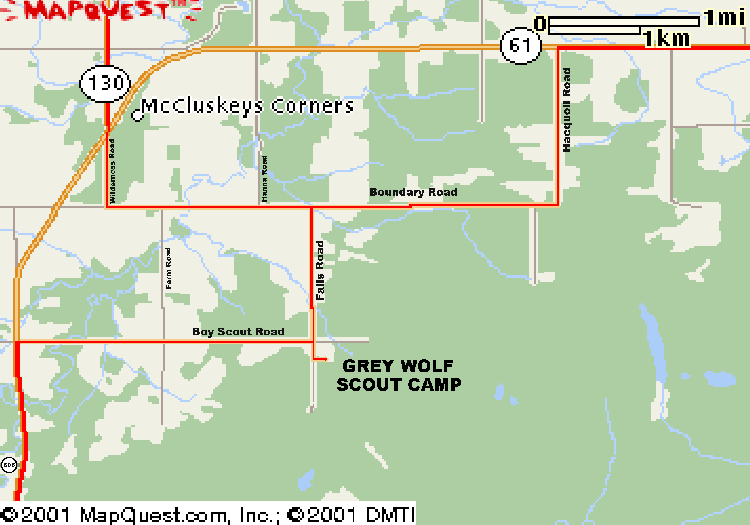
From the junction of Highways 11-17, 61, and Arthur
Street:
- South on Highway 61, 10.5 Km to Hacquoil Road
- Turn Left (South) on Hacquoil Road, travel South 2 Km;
- Right onto Boundary Drive, travel West 2.7 Km;
- Turn Left on Falls Road, travel South 1.7 Km.
- Grey Wolf gate is just South of the first intersection, (Boy
Scout Road) on Falls Road.
From the West on Highway 11-17:
- 14 Km East of Kakabeka Falls, (and East of the weigh
scales)
turn South on Highway 130;
- Travel South (and West) 12.5 Km to Junction Highway 61.
- Turn right onto Highway 61 and immediately left onto
Wilderness Road;
- Travel South 1 Km to Boundary Road;
- Turn left, travel 2 Km East to Falls Road;
- Turn right (South) onto Falls Road, travel South 1.7 Km.
- Grey Wolf gate is just South of the intersection, (Boy Scout
Road) on Falls Road.
From the USA (or South Gillies):
- From Canadian Customs, Travel 38 Km North on Highway 61.
(about 23 miles. Boy Scout Road is 1.2 Km North of Junction
Highway 608.)
- Turn right (East) onto Boy Scout Road;
- Travel 3.2 Km East to Falls Road;
- Turn right (South) onto Falls Road.
- Grey Wolf gate is just South of the intersection, (Boy Scout
Road) on Falls Road.
|